Glendale, California
| City of Glendale | |||
|---|---|---|---|
| — City — | |||
 |
|||
|
|||
| Nickname(s): The Jewel City | |||
 |
|||
| Coordinates: | |||
| Country | |||
| State | |||
| County | Los Angeles | ||
| Incorporated | February 16, 1906 | ||
| Government | |||
| - Type | Council-Manager | ||
| - City Council | Mayor Ara Najarian (R) Frank Quintero John Drayman Laura Friedman Dave Weaver |
||
| - City Attorney | Scott H. Howard | ||
| - City Treasurer | Ronald t. Borucki | ||
| - City Manager | James E. Starbird | ||
| Area | |||
| - Total | 30.7 sq mi (79.4 km2) | ||
| - Land | 30.66 sq mi (79.3 km2) | ||
| - Water | 0.04 sq mi (0.1 km2) | ||
| Elevation | 522 ft (159 m) | ||
| Population (May 1, 2010) | |||
| - Total | 207,902 | ||
| - Density | 6,770.6/sq mi (2,614.16/km2) | ||
| estimated | |||
| Time zone | PST (UTC-8) | ||
| - Summer (DST) | PDT (UTC-7) | ||
| ZIP code | 91201-91210, 91221, 91222, 91225, 91226 | ||
| Area code(s) | 818 | ||
| FIPS code | 06-30000 | ||
| GNIS feature ID | 1660679 | ||
| Website | ci.glendale.ca.us | ||
Glendale (pronounced /ˈɡlɛndeɪl/) is a middle class city in Los Angeles County, California, United States. According to Mapping L.A. by the Los Angeles Times, the average income in Glendale is $57,112 which is considered about average for the County of Los Angeles[1]. It lies at the eastern end of the San Fernando Valley, is bisected by the Verdugo Mountains, and is a suburb in the Greater Los Angeles Area. The city is bordered to the northwest by the Sun Valley and Tujunga neighborhoods of Los Angeles; to the northeast by La Cañada Flintridge and the unincorporated area of La Crescenta; to the west by Burbank and Griffith Park; to the east by Eagle Rock and Pasadena; to the south by the Atwater Village neighborhood of Los Angeles; and to the southeast by Glassell Park neighborhood of Los Angeles. The Golden State, Ventura, Glendale, and Foothill freeways run through the city. The city is policed by the Glendale Police Department.
As of the 2000 census, the city population was 194,973. Since then, there have been estimates of 201,326 by the U.S. Census Bureau in 2004, 207,007 by the California State government in 2005, and 207,303 as listed by the California Department of Finance in 2009 [2], making it the third largest city in Los Angeles County and the seventeenth largest city in the state of California.
Glendale is famous for having helped—in conjunction with Burbank -- father the emerging age of aviation, with its now retired Grand Central Airport.
Glendale's Forest Lawn Memorial Park Cemetery contains the remains of many celebrities and local residents. It is famous as the pioneer of a new style of cemetery.
Glendale is home to one of the largest concentrations of Armenian-Americans in the United States. One quarter of Glendale is Armenian-American.
Contents |
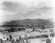
History
The area was long inhabited by the Tongva people.
José María Verdugo, a corporal in the Spanish army from Baja California, received a grant of the Rancho San Rafael in 1798, an area he had been farming since 1784. In 1860 His grandson Teodoro Verdugo built the Verdugo Adobe, which is the oldest building in Glendale. The property is the location of the Oak of Peace where early Californio leaders including Jesus Pico met in 1847 and decided to surrender to Lieutenant Colonel John C. Frémont.
Verdugo's descendants sold the ranch in various parcels, some of which are included in present-day Atwater Village, Eagle Rock, and Highland Park neighborhoods of Los Angeles.
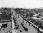
In 1884, residents gathered to form a town and chose the name "Glendale". Residents to the southwest formed "Tropico" in 1887. The Pacific Electric Railway brought streetcar service in 1904.
Glendale incorporated in 1906, and annexed Tropico 12 years later. An important civic booster of the era was Leslie Coombs Brand (1859–1925), who built an estate in 1904 called El Miradero featuring an eye-catching mansion whose architecture combined characteristics of Spanish, Moorish, and Indian styles, copied from the East Indian Pavilion at the 1893 World's Columbian Exposition (World's Fair) held in Chicago, which he visited. Brand loved to fly, and built a private airstrip in 1919 and hosted "fly-in" parties, providing a direct link to the soon-to-be-built nearby Grand Central Airport. The grounds of El Miradero are now city-owned Brand Park and the mansion is the Brand Library, according to the terms of his will.[3]. Brand partnered with Henry E. Huntington to bring the Pacific Electric Railway, or the "Red Cars," to the area. Today, he is memorialized by one of the city's main thoroughfares, Brand Boulevard.
The city's population rose from 13,756 in 1920 to 62,736 in 1930. The Forest Lawn Memorial Park opened in 1917. Pioneering endocrinologist and entrepreneur Dr. Henry R. Harrower opened his clinic in Glendale in 1920, which for many years was the largest business in the city. The American Green Cross, an early conservation and tree preservation society, was formed in 1926 (it disbanded three years later and the current organization of that name is unrelated). In 1964, Glendale was selected by George Lincoln Rockwell to be the West Coast headquarters of the American Nazi Party. Its offices, on Colorado Street in the downtown section of the city, remained open until the early 1980s.
Industry and development
- Grand Central Airport was a municipal airport developed from 1923 which became the largest employer in Glendale for many years, and contributed to the development of aviation in the United States in many important ways. The main terminal building still stands and includes both art deco and Spanish style architectural elements. The facility was the first official terminal for the Los Angeles area as well as the departure point for the first commercial west to east transcontinental flight flown by Charles Lindbergh. During World War II, the Grand Central Air Terminal building was camouflaged to protect it from enemy targeting. It was closed down in 1959, and made way for the Grand Central Business Park.
- The Bob's Big Boy chain of hamburger restaurants started in Glendale on East Colorado in August 1936, and the Baskin-Robbins, "31 Flavors" chain of ice cream parlors started in Adams Square in 1945.
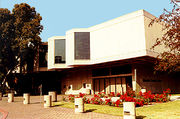
- The Glendale Public Library[4] on Harvard Street houses its "Special Collections" department which contains original documents and records on much of the history of Glendale. It also contains one of the largest collections of books on cats in the world, over 20,000 volumes.[5] It was donated to the library in the 1950s by the Jewel City Cat Fanciers Club, with the understanding that it would be made into a special collection and kept permanently for club members to use and enjoy.[6]
- Completion of the new Glendale Central Library
The city saw significant development in the 1970s.
- Completion of the Glendale Freeway (HWY 2) and the Ventura Freeway (HWY 134).
- Redevelopment of Brand Boulevard, renovation of the 1925 Alex Theatre, and construction of the Glendale Galleria shopping mall which opened in 1976.
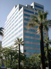
- Several large companies have offices in Glendale. The U.S. headquarters of the Swiss foods multinational Nestlé and International House of Pancakes are located in Glendale. The Los Angeles regional office of California's State Compensation Insurance Fund is in Glendale. Americas United Bank was formed here in 2006 and their headquarters are located in Glendale. Nero AG, the software company that makes Nero Burning ROM, also has its main North American subsidiary located in Glendale. Panda Security, a large antivirus software company, also has its principal U.S. office in Glendale. Neopets, Inc., a company that created the popular virtual pet website, Neopets, is located in the city (it was sold in 2005 to Viacom).
- In 1994, Steven Spielberg, Jeffrey Katzenberg and David Geffen formed DreamWorks SKG, a diversified entertainment company. The company's animation section is located in the city's Grand Central Business Park on land formerly occupied by a helicopter landing base on the old air field. The Walt Disney Company also has a large campus located in the Grand Central Business Park that includes the headquarters for its Imagineering division, and also owns what's left of Grand Central Terminal. Part of KABC-TV has located there.
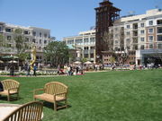
- In 2005, construction began near to the Galleria of developer Rick Caruso's "Americana at Brand", a 15.5 acre outdoor shopping and residential community. Caruso had previously designed and built The Grove at Farmers Market. The new Glendale development was opened to the public on May 2, 2008, and features 75 shops and restaurants, 238 apartments, 100 condominiums, and a Pacific Theatres 18-plex Cinema which seats 3000 people.[7]
Economy
According to the City's 2008 Comprehensive Annual Financial Report,[8] the top employers in the city are:
| # | Employer | # of Employees |
|---|---|---|
| 1 | City of Glendale | 2,565 |
| 2 | Nestle Company | 2,153 |
| 3 | Glendale Adventist Medical Center | 2,112 |
| 4 | Glendale Community College District | 1,442 |
| 5 | Glendale Unified School District | 1,328 |
| 6 | Glendale Memorial | 1,300 |
| 7 | Public Storage Inc. | 1,036 |
| 8 | Walt Disney Imagineering | 902 |
| 9 | Bank America North America | 815 |
| 10 | Acco Engineering Systems | 786 |
Crime
Glendale police officers took on bootleggers and airmen in the 1920s, a decade when the department had both a "liquor detail" and an "air policeman" charged with citing pilots for flying violations committed over the city. In 1944, the Glendale city manager took on Police Chief V.B. Browne over suspected officer corruption, and Browne was asked to resign for failing to control his staff. But Browne asked to stay on as a patrolman, and he walked a beat until his retirement in 1948.
Glendale lost four police officers in the line of duty. The first officer in the area killed in the line of duty was Charles Whitney Smith, marshal for the city of Tropico, later annexed by Glendale. Smith had already been told he was fired, but he wanted to finish his day. So on his last day, Jan. 9, 1915, he was shot to death when he tried to stop a robbery suspect on a street car.
Glendale police officer Leslie O. Clem was killed in a motorcycle accident in 1926 while pursuing a suspect's car. During the course of the pursuit his motorcycle struck streetcar tracks, causing Officer Clem to be thrown from the bike. He succumbed to his injuries the next day.
In 1997, Charles Lazzaretto became the first Glendale police officer in 25 years to die in the line of duty when an attempted-murder suspect, holed up in a Chatsworth warehouse, shot Lazzaretto in the head. In the ensuing gunfight, the suspect was slain and two Los Angeles police officers wounded. Glendale police officer John Isaacson was killed in an automobile accident while on duty in 1972.
In 1985, "Night Stalker" Richard Ramirez terrorized the Los Angeles area, including Glendale. He was linked to the death of Max Kneiding and his wife, Lela Ellen, who were shot to death in their Glendale home. Ramirez also was later linked to a slaying just south of Glendale's Forest Lawn Memorial Park. In an earlier case, Angelo Buono, a Glendale auto upholsterer, was convicted of sexually torturing and murdering nine women whose bodies were dumped on Los Angeles-area hillsides in 1977 and 1978.
In June 1990, an arson fire damaged or destroyed 64 homes in Glendale's San Rafael Hills and caused $40 million in damage. Evening rush-hour traffic was brought to a halt at the height of the fire as flames burned on both sides of the Glendale Freeway. The 100-acre fire, one of the worst in the city's history, resulted in flames leapfrogging from house to house, destroying some, leaving others untouched. After the devastating fire, the Glendale City Council passed a brush-clearing ordinance that called for more frequent inspection of private property by fire officials, and it allowed firefighters to cut back overgrown brush on private property and charge owners for the work.
On February 6, 1996, seven people were killed in the worst arson-murder in the city's history. The fire killed a Glendale mother, Turan Avanesian, and her six children, from ages 4 to 17. Jorjik Avanesian, who was convicted of dousing his family's one-bedroom apartment in Glendale with gasoline and setting it on fire, later killed himself in jail.
In 2005, 11 people died and about 180 were injured in a Metrolink (Southern California) train accident when a man who later claimed he was suicidal parked his sport utility vehicle on the tracks in Glendale. The driver was convicted of murder.
Gangs
Glendale was once home to more than 30 different gangs. Gang violence peaked in the '90s. Over time, the numbers have dropped significantly, and now there are only five documented gangs in the city.[9] Gang activity is primarily located in the low-income, Hispanic area of South Glendale, bordering the Northeast Los Angeles neighborhoods of Atwater Village, and Glassell Park. Historically, South Glendale is claimed by the Mexican gang Tooner Ville Rifa. The gang's ongoing attempt to control this area has led to turf wars between it and rival gangs from the bordering cities. Even the arrest and conviction of one of the gang's leaders has done little to stop gang activity. The problem has pushed Glendale and Los Angeles city officials to seek an injunction against the gang, covering 4.5 square-miles. This area is bordered by the Los Angeles River, the Glendale Freeway, and the streets of Broadway and Verdugo Road.[10] In 2009, TVR was listed as one of LAPD's top 14 targeted street gangs.[11]
Another primary source of Glendale's gang problem is the Avenues gang, which has also been listed as one of the LAPD's top 14 targeted street gangs. On June 25th, 2008, over 500 officers, including SWAT teams, participated in a take-down of the gang. A clique leader was arrested in the 900 block of East Windsor in South Glendale.[12]
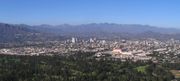
Geography
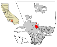
Glendale is located at (34.170939, -118.250081)[13] at the juncture of two large valleys, the San Fernando and the San Gabriel. According to the United States Census Bureau, the city has a total area of 79.4 km2 (30.7 sq mi). 79.4 km² (30.6 mi²) of it is land and 0.1 km² (0.04 mi²) of it (0.07%) is water. It is bordered to the north by the foothill communities of La Canada Flintridge, La Crescenta, and Tujunga; to the south by the Atwater Village community incorporated by the city of Los Angeles; to the east by Pasadena and Eagle Rock (also incorporated within Los Angeles); and to the west by the city of Burbank.
Neighborhoods of Glendale: - El Miradero - Pelanconi - Fremont Park - Riverside Rancho - Glenwood - Grandview - Grand Central - Brockmont - Rossmoyne - Greenbriar - Emerald Isle - Rancho San Rafael - San Rafael Hills - Adams Hill - College Hills - Chevy Chase - Glenoaks Canyon - Citrus Grove - Moorpark - Tropico - Pacific Edison - Mariposa - Somerset - Vineyard - Woodbury - Montecito Park - Sparr Heights - Oakmont - Whiting Woods - Crescenta Highlands - Verdugo Viejo - Verdugo Woodlands - Verdugo City - Downtown Glendale
Geology
Several known earthquake faults criss-cross the Glendale area and adjacent mountains, as they do most of southern California. Among the more recognized faults by seismologists are the Sierra Madre and Hollywood faults, which are situated in the city's northern and southwestern portions, respectively. Additionally, the Verdugo and Raymond faults intersect through the city's central and southeastern areas. The San Gabriel fault, meanwhile, is located northeast of the city. Roughly 75 miles northeast of Glendale, there's a major part of the San Andreas fault known as the "Big Bend," where quake-recurrence tracking shows major activity roughly every 140–160 years. The closest portion of the San Andreas is actually 29 miles from Glendale. The last major quake along the southern San Andreas was recorded in 1857.
In the 1971 San Fernando Earthquake, which took place along the western edge of the Sierra Madre fault, there were surface ruptures nearly 12 miles long, including one portion a few miles northwest of Glendale. Most of the damage was in the northern San Fernando Valley, although 31 structures in Glendale suffered major damage and had to be demolished, plus dozens of chimneys were toppled. The 1994 Northridge Earthquake had an epicenter about 18 miles from Glendale. The city suffered severe damage to a public parking structure and sections of the Glendale Galleria parking structures and exterior columns incurred damages.[14]
Climate
Glendale has a Mediterranean climate (Köppen climate classification Csa).
| Climate data for Glendale | |||||||||||||
|---|---|---|---|---|---|---|---|---|---|---|---|---|---|
| Month | Jan | Feb | Mar | Apr | May | Jun | Jul | Aug | Sep | Oct | Nov | Dec | Year |
| Record high °C (°F) | 34 (93) |
33 (91) |
36 (97) |
41 (106) |
39 (102) |
43 (109) |
43 (109) |
42 (108) |
43 (109) |
42 (108) |
37 (99) |
34 (93) |
43 (109) |
| Average high °C (°F) | 19.4 (66.9) |
21.1 (70) |
23.9 (75) |
25.0 (77) |
28.3 (82.9) |
31.7 (89.1) |
32.2 (90) |
30.6 (87.1) |
27.8 (82) |
23.3 (73.9) |
21.7 (71.1) |
20.0 (68) |
25.4 (77.7) |
| Average low °C (°F) | 5.6 (42.1) |
6.7 (44.1) |
10.0 (50) |
12.2 (54) |
14.4 (57.9) |
16.7 (62.1) |
16.7 (62.1) |
15.6 (60.1) |
12.2 (54) |
7.8 (46) |
7.2 (45) |
5.0 (41) |
10.8 (51.4) |
| Record low °C (°F) | -5 (23) |
-8 (18) |
-5 (23) |
1 (34) |
3 (37) |
5 (41) |
7 (45) |
9 (48) |
7 (45) |
3 (37) |
-2 (28) |
-3 (27) |
-8 (18) |
| Precipitation mm (inches) | 90.4 (3.56) |
109 (4.29) |
98.6 (3.88) |
25.9 (1.02) |
9.4 (.37) |
3 (.12) |
0.5 (.02) |
4.6 (.18) |
8 (.3) |
14 (.55) |
26.7 (1.05) |
54.6 (2.15) |
444.2 (17.49) |
| Source: [15] | |||||||||||||
- Highest Recorded Temperature: 43°C
- Lowest Recorded Temperature: -8 °C
- Warmest Month: August
- Coolest Month: January
- Highest Precipitation: February
- Lowest Precipitation: July
Demographics
| Historical populations | |||
|---|---|---|---|
| Census | Pop. | %± | |
| 1910 | 2,746 |
|
|
| 1920 | 13,536 | 392.9% | |
| 1930 | 62,736 | 363.5% | |
| 1940 | 82,582 | 31.6% | |
| 1950 | 95,702 | 15.9% | |
| 1960 | 119,442 | 24.8% | |
| 1970 | 132,664 | 11.1% | |
| 1980 | 139,060 | 4.8% | |
| 1990 | 180,038 | 29.5% | |
| 2000 | 194,973 | 8.3% | |
| Est. 2007 | 200,859 | 3.0% | |
Foreign-born residents accounted for 54% of the population in 2000.
As of the census[16] of 2000, there were 194,973 people, 71,805 households, and 49,617 families residing in the city. The population density was 2,456.1/km² (6,362.2/mi²). There were 73,713 housing units at an average density of 928.6/km² (2,405.3/mi²). The racial makeup of the city was 63.6% White, 1.6% Black or African American, 0.3% Native American, 16.1% Asian American, 0.1% Pacific Islander, 8.6% from other races, and 10.1% from two or more races. 19.7% of the population were Hispanic or Latino of any race.
There were 71,805 households out of which 32.9% had children under the age of 18 living with them, 52.3% were married couples living together, 11.8% had a female householder with no husband present, and 30.9% were non-families. 25.7% of all households were made up of individuals and 8.7% had someone living alone who was 65 years of age or older. The average household size was 2.68 and the average family size was 3.27.
In the city the population was spread out with 22.4% under the age of 18, 8.4% from 18 to 24, 32.2% from 25 to 44, 23.1% from 45 to 64, and 13.9% who were 65 years of age or older. The median age was 38 years. For every 100 females there were 91.3 males. For every 100 females age 18 and over, there were 88.0 males.
The median income for a household in the city was $41,805, and the median income for a family was $47,633. Males had a median income of $39,709 versus $33,815 for females. The per capita income for the city was $22,227. About 13.6% of families and 15.5% of the population were below the poverty line, including 20.7% of those under age 18 and 11.9% of those age 65 or over.
Armenian population
_crop.JPG)
Armenian families have lived in the city since the 1920s, but the surge in immigration escalated in the 1970s. Armenian-Americans are well integrated into the city, with many businesses, several Armenian schools, and ethnic/cultural organizations serving this ethnic group. Glendale has the highest percentage of residents of Armenian descent, most of whom arrived in the city in the last two decades. The city of Glendale is home to the third largest Armenian community outside of Armenia, after Moscow and Los Angeles. According to the United States 2000 Census Glendale is home to 53,854 Armenian-Americans [17] (making up 27.6% of the total population), increasing from 1990 when there were 31,402 Armenian-Americans in the city.[18] As of 2009, one of the five members of Glendale's city council is of Armenian descent—Ara J. Najarian. Former Armenian-American mayors of Glendale include Larry Zarian, Bob Yousefian, Rafi Manoukian, and Ara Najarian.
Some outspoken members of the highly successful Armenian-American rock band, System Of A Down, were based in Glendale at the time of formation. These include singer Serj Tankian and bassist Shavo Odadjian.[19],[20].
Law Enforcement and Medical Services
Glendale maintains its own police departmant. The police department operates out of its main station in Downtown Glendale, its Downtown substation in the Glendale Galleria and the Montrose substation in Verdugo City. Parks and open mountain space are patrolled by the Glendale Park Rangers. The Glendale Park Rangers maintain their headquarters in Deukmejian Wilderness Park and also have a substation in Brand Park. The California Highway Patrol has its Southern Division Headquarters in Downtown Glendale. Glendale also maintains its own class one fire department. Ambulance service is provied by Glendale fire paramedics and Glendale fire basic life support(BLS) ambulances.
Government
Local Government
According to the city’s most recent Comprehensive Annual Financial Report, the city’s various funds had $575.6 million in Revenues, $542.8 million in expenditures, $2,089.7 million in total assets, $480.9 million in total liabilities, and $460.4 million in cash and investments.[21]
The structure of the management and coordination of city services is:[21]
| City Department | Director |
|---|---|
| City Manager | James E. Starbird |
| Assistant City Manager | Robert K. McFall |
| Deputy City Manager | Yasmin Beers |
| Director of Glendale Water & Power | Glen O. Steiger |
| Police Chief | Ron De Pompa |
| Fire Chief | Harold Scoggins |
| Director of Public Works | Stephen Zurn |
| Director of Finance and Administrative Services | Robert Elliot |
| Director of Human Resources | Matthew Doyle |
| Director of Development Services | Philip Lanzafame |
| Director of Planning | Hassan Haghani |
| Director of Community Development and Housing | (vacant) |
| Director of Information Services | |
| Director of Parks, Recreation and Community Services | George Chapjian |
| Director of Library Services | Cindy Cleary |
County representation
The Los Angeles County Department of Health Services operates the Glendale Health Center in Glendale.[22]
Politics
The city of Glendale, along with neighboring Burbank and Pasadena, falls under California's 29th district in the United States House of Representatives. Congressman Adam Schiff has represented the district since 2000, and his vocal stances on issues regarding US-Armenia relations reflect the large Armenian presence in the district.
In the state legislature Glendale is located in the 21st Senate District, represented by Democrat Carol Liu, and in the 38th (4%) and 43rd (96%) Assembly Districts, represented by Republican Cameron Smyth and Democrat Mike Gatto respectively. Federally, Glendale is located in California's 29th congressional district, which has a Cook PVI of D +12[23] and is represented by Democrat Adam Schiff.
Education
The Glendale Unified School District operates the public schools in Glendale. The GUSD high schools include:
- Glendale High School
- Herbert Hoover High School
- Clark Magnet High School
- Crescenta Valley High School located in La Crescenta.
- Allan F. Daily High School (Continuation)
A number of private schools also operate in Glendale:
- Chamlian Armenian School[24]
- Holy Family High School
- Salem Lutheran School
- Glendale Adventist Academy.
Glendale is also home to Glendale Community College.
Transportation
Glendale offers many transportation options. LADOT, Metro Local, Metro Rapid and Glendale Beeline all have buses that run in the city. GTC (Glendale Transportation Center) provides connections to Greyhound and three train lines. Glendale is also served by four freeways: the Glendale Freeway (State Route 2), the Ventura Freeway (State Route 134), the Foothill Freeway (Interstate 210) and the Golden State Freeway (Interstate 5).
Shopping
Glendale has many options for shopping including; Glendale Galleria which is anchored by Nordstrom, Macy's, Target and J. C. Penney, The Americana at Brand which is an up-scale outdoor mall (similar to The Grove in L.A.) some stores include, H&M, A/X Armani Exchange, True Religion, Michael Stars, Lacoste, Urban Outfitters, etc...[25] and the Glendale Fashion Center which is anchored by Ross, TJ Max, Nordstrom Rack, Staples, Petco and many others. Shopping can also be done at Montrose Shopping Park in North Glendale. The shopping park runs down Honolulu Ave and is filled with many stores and restaurants.
Community organizations
The City of Glendale includes a variety of nonprofit organizations that enhance the quality of life in Glendale. Strong links between local residents, business owners, and government have created a network of organizations that provide support in the areas of education, employment, homeless services, after-school activities, and social services. Local organizations include:
- The Salvation Army Glendale
- The Kiwanis Club of Glendale
- Glendale Community Free Health Clinic
- PATH Achieve Glendale (Homeless Access Center & Shelter)
- Glendale Healthy Kids
- Glendale Historical Society
Sister cities
Currently, Glendale has the following sister cities.[26] [27]
 Kapan, Armenia
 Higashiosaka, Japan
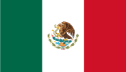 Tlaquepaque, Mexico
- Rosarito Beach, Baja California, Mexico
- Hiroshima, Japan
 Goseong,South Korea
Notable residents
A number of notable people are natives of or have lived in Glendale, including:
|
|
See also
- List of cities in California
- Largest cities in Southern California
Notes
- ↑ "Mapping L.A.". Los Angeles Times. 2010-05. http://projects.latimes.com/mapping-la/neighborhoods/neighborhood/glendale/. Retrieved 2005-10-20.
- ↑ "E-1 Population Estimates for Cities, Counties and the State with Annual Percent Change — January 1, 2008 and 2009". California Department of Finance. 2009-05. http://www.dof.ca.gov/research/demographic/reports/estimates/e-1/2008-09/. Retrieved 2009-05-02.
- ↑ The Brand legacy, Mansion and Library
- ↑ "City of Glendale, CA — Library". http://www.ci.glendale.ca.us/library/default.asp.
- ↑ "The 20,000 books ... on cats is the largest such collection in the world." Pitt, Leonard; Dale Pitt (1997). "Glendale". Los Angeles A to Z (1 ed.). Los Angeles: University of California Press.
- ↑ Personal communication by Wikipedia editor "JesseW" with Glendale head reference librarian, 20 June 2005 (UTC).
- ↑ L.A. Times issue 25 April 2005
- ↑ City of Glendale CAFR Retrieved 2009-08-12
- ↑ Police Go On Gang Offensive
- ↑ L.A., Glendale seek injunction against Toonerville gang
- ↑ Los Angeles Police Department 2009 Gang Initiatives
- ↑ FEDERAL RACKETEERING INDICTMENT TARGETS MEMBERS OF VIOLENT DREW STREET GANG IN NORTHEAST LOS ANGELES
- ↑ "US Gazetteer files: 2000 and 1990". United States Census Bureau. 2005-05-03. http://www.census.gov/geo/www/gazetteer/gazette.html. Retrieved 2008-01-31.
- ↑ http://www.ci.glendale.ca.us/pdf/HMP/HMP_Sec-6_Earthquakes.pdf
- ↑ "Glendale historic weather averages". Intellicast. http://www.intellicast.com/Local/History.aspx?location=USCA0423. Retrieved 9 October 2009.
- ↑ "American FactFinder". United States Census Bureau. http://factfinder.census.gov. Retrieved 2008-01-31.
- ↑ U.S. Census Bureau - Ancestry:2000 - Glendale city, California
- ↑ ARMENIAN POPULATION UP VALLEY, GLENDALE AND BURBANK SHOW BIG PERCENTAGE HIKES.
- ↑ http://en.wikipedia.org/wiki/System_of_a_Down
- ↑ www.systemofadown.com
- ↑ 21.0 21.1 City of Glendale CAFR Retrieved 2009-08-12
- ↑ "Glendale Health Center." Los Angeles County Department of Health Services. Retrieved on March 27, 2010.
- ↑ "Will Gerrymandered Districts Stem the Wave of Voter Unrest?". Campaign Legal Center Blog. http://www.clcblog.org/blog_item-85.html. Retrieved 2008-02-10.
- ↑ http://www.chamlian.org
- ↑ http://www.americanaatbrand.com/shopping.html
- ↑ Sister Cities International
- ↑ Hicken, Melanie, "Mayor Returns from Korea", Glendale News Press, Glendale, 31 August 2010. Retrieved 2010-08-31.
- ↑ Dan Miller (2009-08-21). "Up Close with Julia Ann". AVN. http://business.avn.com/articles/36143.html. Retrieved 2009-10-31.
- ↑ Glick, Shav (1987-10-20). "Auto Races Once Again Replacing Horse Races". Los Angeles Times. http://articles.latimes.com/1987-10-20/sports/sp-14564_1_del-mar. Retrieved 22 July 2010. ""Mays, a handsome 6-footer who was born and raised in Riverside and spent most of his adult years in Glendale,""
External links
- City of Glendale - official
- Glendale Water & Power - official
- Glendale Chamber of Commerce
- Glendale Community College
- Glendale Unified School District
- Think Glendale
- Glendale News-Press - local media
|
||||||||||||||||||||
|
|||||||||||||||||||||||||||
|
|||||||||||||||||||||||
|
|||||||||||||||||
|
|||||||||||||||||||||||||||||||||||||||||||||||||||||
 |
Los Angeles | La Cañada | Altadena | |
| Burbank | Pasadena | |||
| Hollywood | Los Angeles | South Pasadena |